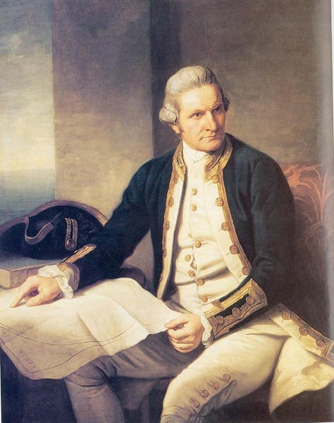
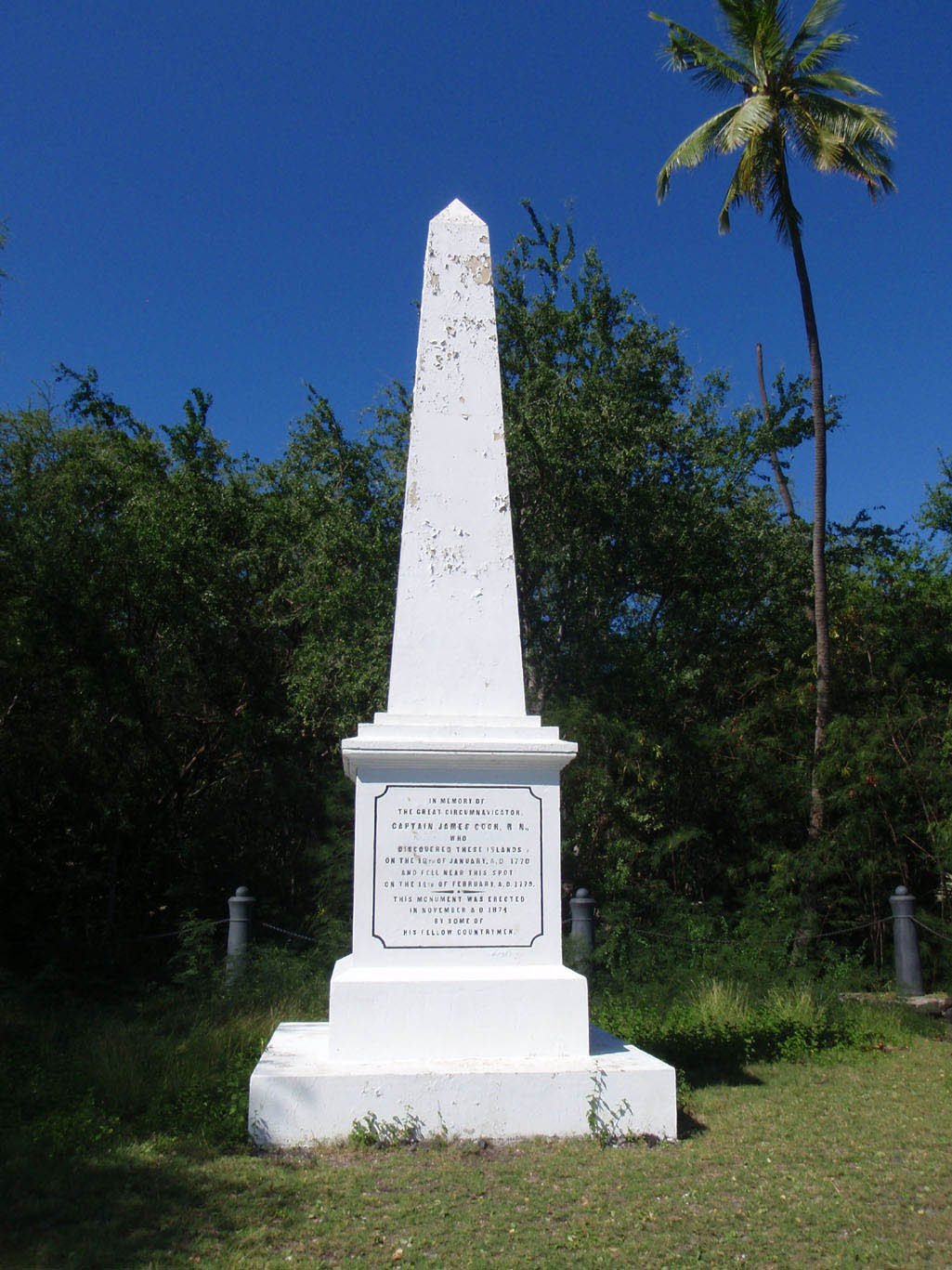
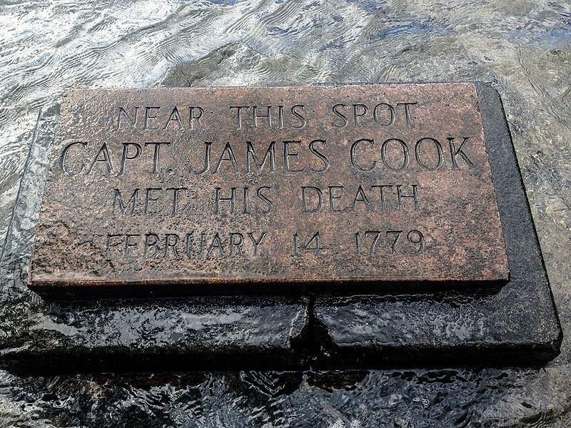
English Navigator, Explorer, and Mapmaker. He is remembered for his three exploration voyages that circumnavigated the globe and for his discovery of the Sandwich Islands (now known as the Hawaiian Islands). Born the second of eight children, his father was a farm laborer. In 1736 his family moved to Airey Holme farm at Great Ayton, North Yorkshire, England and his father's employer paid for him to attend the local school. In 1741 he began working for his father and four years later he moved to Staithes, England and worked for a grocer. 18 months later he became a merchant navy apprentice for ship-owners in the port town of Whitby, England. As part of his apprenticeship, he applied himself to the study of algebra, geometry, trigonometry, navigation and astronomy, skills he would need one day to command his own ship. After completing his three-year apprenticeship, he began working on trading ships in the Baltic Sea. In 1752 he passed his examinations and soon progressed through the merchant navy ranks. In 1755 he volunteered for service in the Royal Navy, when England was re-arming for what was to become the Seven Years' War (also known as the French and Indian War) and he entered the Navy in June of that year. His first posting was with the HMS Eagle, sailing with the rank of master's mate. In October and November 1755 he took part in the capture of one French warship and the sinking of another, following which he was promoted to the rank of boatswain, in addition to his other duties. His first temporary command was in March 1756 when he was briefly the master of the Cruizer, a small cutter attached to the Eagle while on patrol. In June 1757 he passed his master's examinations at Trinity House, Deptford, England which qualified him to navigate and handle a ship of the King's fleet. He then joined the frigate HMS Solebay. In 1758, serving aboard the Pembroke, he took part in the major amphibious assault that captured the Fortress of Louisbourg from the French, after which he participated in the siege of Quebec City and then the Battle of the Plains of Abraham in 1759. He showed a talent for surveying and cartography, and was responsible for mapping much of the entrance to the Saint Lawrence River during the siege, thus allowing English Major General James Wolfe to make his famous stealth attack on the Plains of Abraham. His surveying ability was put to good use mapping the jagged coast of Newfoundland and from 1760 to 1765 he produced the first large-scale and accurate maps of the island's coasts and were the first scientific, large scale, hydrographic surveys to use precise triangulation to establish land outlines. It also demonstrated his mastery of practical surveying, achieved under often adverse conditions, and brought him to the attention of the Admiralty and Royal Society. In 1766 the Royal Society engaged him to travel to the Pacific Ocean to observe and record the transit of Venus across the Sun. At the age of 39 he was promoted to lieutenant and named as commander of the expedition that departed England on 26 August 1768 and arrived at the pacific island of Tahiti in April 1769. He continued to New Zealand and mapped the complete coastline, then voyaged west, reaching the south-eastern coast of Australia in April 1770. He returned to England via Batavia (modern Jakarta, Indonesia), the Cape of Good Hope, and arriving at the island of Saint Helena in July 1771. His journals were published upon his return, and he became something of a hero among the scientific community. Shortly after his return from the first voyage, he was promoted to the rank of commander. In 1772 the Royal Society commissioned him to search for Terra Australis, a hypothetical continent first posited in Antiquity and which appeared on maps between the 15th and 18th centuries. He commanded the HMS Resolution on this voyage, circumnavigating the globe at an extreme southern latitude, becoming one of the first to cross the Antarctic Circle on January 17, 1773. He explored the Antarctic and almost encountered the mainland of Antarctica, but turned towards Tahiti to resupply his ship. He then resumed his southward course in a second fruitless attempt to find the supposed continent. On his return voyage to New Zealand in 1774, he landed at the Friendly Islands, Easter Island, Norfolk Island, New Caledonia, and Vanuatu. Before returning to England, he made a final sweep across the South Atlantic from Cape Horn and surveyed, mapped and took possession for Britain the Island South Georgia. His reports upon his return home put to rest the popular myth of Terra Australis. He was promoted to the rank of post-captain and given an honorary retirement from the Royal Navy, with a posting as an officer of the Greenwich Hospital. He was made a Fellow of the Royal Society, and awarded the Copley Gold Medal. He then volunteered to take a 3rd voyage to find the Northwest passage and in 1776 he left aboard the HMS Resolution to the Pacific Ocean, landed in Tahiti and sailed north to find the Northwest Passage. In 1778 he became the first European to discover the Hawaiian Islands, naming them the Sandwich Islands, in honor of the Earl of Sandwich, the Acting First Lord of the Admiralty. He then sailed north and then northeast to explore the west coast of North America, making landfall on the present-day Oregon coast, and soon after entered Nootka Sound on Vancouver Island where he encountered the indigenous First Nations people. After leaving Nootka Sound, he explored and mapped the coast all the way to the Bering Strait, on the way identifying what came to be known as Cook Inlet in Alaska. In a single visit he charted the majority of the North American north-west coastline on world maps for the first time, determined the extent of Alaska, and closed the gaps in Russian (from the West) and Spanish (from the South) exploratory probes of the Northern limits of the Pacific. He then made several attempts to navigate the Bering Strait which proved to be impassable, and he returned to Hawaii. After sailing around the archipelago for some eight weeks, he made landfall at Kealakekua Bay, on 'Hawaii Island', largest island in the Hawaiian Archipelago. After a month's stay, he attempted to resume his exploration of the Northern Pacific. Shortly after leaving Hawaii Island, the Resolution's foremast broke, so the ships returned to Kealakekua Bay for repairs. Tensions soon rose, and a number of quarrels broke out between his crew and the Hawaiians at Kealakekua Bay. When one of his small boats was taken by an unknown group of Hawaiians, he was forced into a wild goose chase that ended with his return to the ship frustrated. The following day he went to the village to take their King, Kalani'ōpu'u, hostage and in a confrontation with the Hawaiians, he was killed at the age of 50. The Hawaiians took his body back to their village and prepared it with funerary rituals usually reserved for the chiefs and highest elders of their society, and some of his remains, thus preserved, were eventually returned to his crew for a formal burial at sea. A white obelisk monument to his honor was erected in November 1874 at Kealakekua Bay to mark the spot where he died. Additionally, a memorial statue in his honor is located at the Catani Gardens in St Kilda, Victoria, Australia, at Hofgaard Park in Waimea, Hawaii, and also in Greenwich, London, England. A US coin, the 1928 Hawaiian Sesquicentennial half dollar minted for the 150th anniversary of his discovery of the islands, bears his image.
English Navigator, Explorer, and Mapmaker. He is remembered for his three exploration voyages that circumnavigated the globe and for his discovery of the Sandwich Islands (now known as the Hawaiian Islands). Born the second of eight children, his father was a farm laborer. In 1736 his family moved to Airey Holme farm at Great Ayton, North Yorkshire, England and his father's employer paid for him to attend the local school. In 1741 he began working for his father and four years later he moved to Staithes, England and worked for a grocer. 18 months later he became a merchant navy apprentice for ship-owners in the port town of Whitby, England. As part of his apprenticeship, he applied himself to the study of algebra, geometry, trigonometry, navigation and astronomy, skills he would need one day to command his own ship. After completing his three-year apprenticeship, he began working on trading ships in the Baltic Sea. In 1752 he passed his examinations and soon progressed through the merchant navy ranks. In 1755 he volunteered for service in the Royal Navy, when England was re-arming for what was to become the Seven Years' War (also known as the French and Indian War) and he entered the Navy in June of that year. His first posting was with the HMS Eagle, sailing with the rank of master's mate. In October and November 1755 he took part in the capture of one French warship and the sinking of another, following which he was promoted to the rank of boatswain, in addition to his other duties. His first temporary command was in March 1756 when he was briefly the master of the Cruizer, a small cutter attached to the Eagle while on patrol. In June 1757 he passed his master's examinations at Trinity House, Deptford, England which qualified him to navigate and handle a ship of the King's fleet. He then joined the frigate HMS Solebay. In 1758, serving aboard the Pembroke, he took part in the major amphibious assault that captured the Fortress of Louisbourg from the French, after which he participated in the siege of Quebec City and then the Battle of the Plains of Abraham in 1759. He showed a talent for surveying and cartography, and was responsible for mapping much of the entrance to the Saint Lawrence River during the siege, thus allowing English Major General James Wolfe to make his famous stealth attack on the Plains of Abraham. His surveying ability was put to good use mapping the jagged coast of Newfoundland and from 1760 to 1765 he produced the first large-scale and accurate maps of the island's coasts and were the first scientific, large scale, hydrographic surveys to use precise triangulation to establish land outlines. It also demonstrated his mastery of practical surveying, achieved under often adverse conditions, and brought him to the attention of the Admiralty and Royal Society. In 1766 the Royal Society engaged him to travel to the Pacific Ocean to observe and record the transit of Venus across the Sun. At the age of 39 he was promoted to lieutenant and named as commander of the expedition that departed England on 26 August 1768 and arrived at the pacific island of Tahiti in April 1769. He continued to New Zealand and mapped the complete coastline, then voyaged west, reaching the south-eastern coast of Australia in April 1770. He returned to England via Batavia (modern Jakarta, Indonesia), the Cape of Good Hope, and arriving at the island of Saint Helena in July 1771. His journals were published upon his return, and he became something of a hero among the scientific community. Shortly after his return from the first voyage, he was promoted to the rank of commander. In 1772 the Royal Society commissioned him to search for Terra Australis, a hypothetical continent first posited in Antiquity and which appeared on maps between the 15th and 18th centuries. He commanded the HMS Resolution on this voyage, circumnavigating the globe at an extreme southern latitude, becoming one of the first to cross the Antarctic Circle on January 17, 1773. He explored the Antarctic and almost encountered the mainland of Antarctica, but turned towards Tahiti to resupply his ship. He then resumed his southward course in a second fruitless attempt to find the supposed continent. On his return voyage to New Zealand in 1774, he landed at the Friendly Islands, Easter Island, Norfolk Island, New Caledonia, and Vanuatu. Before returning to England, he made a final sweep across the South Atlantic from Cape Horn and surveyed, mapped and took possession for Britain the Island South Georgia. His reports upon his return home put to rest the popular myth of Terra Australis. He was promoted to the rank of post-captain and given an honorary retirement from the Royal Navy, with a posting as an officer of the Greenwich Hospital. He was made a Fellow of the Royal Society, and awarded the Copley Gold Medal. He then volunteered to take a 3rd voyage to find the Northwest passage and in 1776 he left aboard the HMS Resolution to the Pacific Ocean, landed in Tahiti and sailed north to find the Northwest Passage. In 1778 he became the first European to discover the Hawaiian Islands, naming them the Sandwich Islands, in honor of the Earl of Sandwich, the Acting First Lord of the Admiralty. He then sailed north and then northeast to explore the west coast of North America, making landfall on the present-day Oregon coast, and soon after entered Nootka Sound on Vancouver Island where he encountered the indigenous First Nations people. After leaving Nootka Sound, he explored and mapped the coast all the way to the Bering Strait, on the way identifying what came to be known as Cook Inlet in Alaska. In a single visit he charted the majority of the North American north-west coastline on world maps for the first time, determined the extent of Alaska, and closed the gaps in Russian (from the West) and Spanish (from the South) exploratory probes of the Northern limits of the Pacific. He then made several attempts to navigate the Bering Strait which proved to be impassable, and he returned to Hawaii. After sailing around the archipelago for some eight weeks, he made landfall at Kealakekua Bay, on 'Hawaii Island', largest island in the Hawaiian Archipelago. After a month's stay, he attempted to resume his exploration of the Northern Pacific. Shortly after leaving Hawaii Island, the Resolution's foremast broke, so the ships returned to Kealakekua Bay for repairs. Tensions soon rose, and a number of quarrels broke out between his crew and the Hawaiians at Kealakekua Bay. When one of his small boats was taken by an unknown group of Hawaiians, he was forced into a wild goose chase that ended with his return to the ship frustrated. The following day he went to the village to take their King, Kalani'ōpu'u, hostage and in a confrontation with the Hawaiians, he was killed at the age of 50. The Hawaiians took his body back to their village and prepared it with funerary rituals usually reserved for the chiefs and highest elders of their society, and some of his remains, thus preserved, were eventually returned to his crew for a formal burial at sea. A white obelisk monument to his honor was erected in November 1874 at Kealakekua Bay to mark the spot where he died. Additionally, a memorial statue in his honor is located at the Catani Gardens in St Kilda, Victoria, Australia, at Hofgaard Park in Waimea, Hawaii, and also in Greenwich, London, England. A US coin, the 1928 Hawaiian Sesquicentennial half dollar minted for the 150th anniversary of his discovery of the islands, bears his image.
Bio by: William Bjornstad
Family Members


Advertisement